The uninhabited archipelago belongs to Australia’s Antarctic regions. It is located about 1600 km north of Antarctica and 4100 km southwest of Perth. The island of Heard is about 368 km², the McDonald Islands together only have an area of around 2 km². They are the only active volcanic islands in Antarctica. On Heard is the 2,745 m high Mawson Peak volcano, the highest mountain on Australian territory. Around 80% of the island’s surface is covered with ice. The islands are one of the few virtually untouched spots on earth. There are no strange plants or animals here.
Heard and McDonald Islands: Facts
Official title:
Heard and McDonald Islands (sub-Antarctic volcanic islands)
Natural monument:
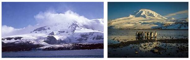
McDonald Islands (18 km²), west of Heard Island (368 km²), and waters within the 12-mile zone; on Heard Island heights up to 2745 m (Mawson Peak), on McDonald Islands up to 230 m; Heard Island is 80% covered by glaciers
Heard Island and McDonald Islands, southern Indian Ocean, Kerguelen Plateau, 4100 km southwest of Perth and 1500 km north of Antarctica
Appointment:
1997
Meaning:
the only active volcanic islands in Antarctica and, due to the lack of non-native plants and animals, an “eco-paradise”
Flora and fauna:
11 vascular plant and 42 moss species on Heard Island, 5 vascular plant and 6 moss species on McDonald Islands; Southern elephant seal and leopard seal on Heard Island, there also important nursery for the Kerguelen fur seal, at McDonald Islands nursery for the southern elephant seal; 34 bird species such as golden crested penguin (up to 2 million pairs) and on Heard Island around 6% of the global gentoo penguin nesting population as well as 3000 pairs of the southern giant petrel, migrating albatrosses brooding for the first time in 1980
Volcanic shoulders under a subpolar sky
If you approach Heard Island, gliding over the crests of the southern Indian Ocean, you will notice a lenticular cloud, the appearance of which is visible in the fog. And if you get a little closer, you will discover that the high ridges of the Mawson Peak volcano, also known as Big Ben, begin to whet this cloud. Gradually the masses of ice on the ridges take on their shape, rise solidly from the damp haze.
40 kilometers away from this volcanic island, probably the roughest and most isolated in the world, one circumvents the small McDonald Islands, jagged outcrops of volcanic origin, with the greatest care and attention. When you look at the map, it becomes clear that you are far from any human civilization: it is 1500 kilometers to the inhospitable Antarctica, 4100 kilometers to the west coast of the fifth continent and 4700 kilometers to southern Africa. What opens before the eye of the beholder, however, takes your breath away: a main island that is only one square kilometer in size, but whose sheer rock rises 230 meters from the sea. Not to be underestimated danger and challenge at the same time is the 130 meter high needle island for those who
If one can finally take a closer look at this island, one immediately perceives its monumental dimensions: Big Ben towers higher than any elevation in distant Australia, to whose national territory the island belongs. The ice masses of the glaciers plunge into the sea, the temperatures of which fluctuate between one and two degrees Celsius. Constant gusts of wind from the west with an average of 26 to over 33 kilometers per hour make this piece of earth one of the most inhospitable on our planet. Hurricanes with wind speeds of up to 209 kilometers per hour have also been measured. And these climatic conditions and the rugged landscape profile form the prerequisites for those sub-Antarctic Australian islands to be a completely isolated laboratory with an unadulterated flora and fauna. But the ruthless nature with its powers did not always rule this island kingdom alone. From the mid-19th century to the 1920s, sealers headed for the islands to slaughter seals and king penguins. Oil was extracted from both, and seal pelts were also used. After the collapse of the seal hunt, it was possible for the populations of native animal species to recover undisturbed. Only scientists subsequently set foot on the islands and began their investigations from 1947 onwards. on top of that, the seal pelts were used. After the collapse of the seal hunt, it was possible for the populations of native animal species to recover undisturbed. Only scientists entered the islands in the period that followed and began their investigations from 1947 onwards. on top of that, the seal pelts were used. After the collapse of the seal hunt, it was possible for the populations of native animal species to recover undisturbed. Only scientists subsequently set foot on the islands and began their investigations from 1947 onwards.
Although the heart of an adventurer may beat faster at the sight of Big Ben, it has only been possible to climb its storm-lashed summit twice so far. Such temptations of a rough, inhospitable landscape remain challenges for few. Even those who have ever set foot on land will only find places where the ice sheets have retreated from the coastal fringes that have been able to discover flora and fauna untouched by human hands for more than seven decades. Only a dozen vascular plants and plant communities of the fells and the alpine meadows can thrive in these latitudes, including a large number of moss and lichen species. If you walk along the coast, you can certainly enjoy the parade of penguins waddling around. Meanwhile, seagull petrels rummage through lush green Azorella cushions for food while numerous fur seals doze on the beach. On the islands, humans resemble a »migratory bird«, while fur seals and penguins are the true children and heirs of this untouched nature on the edge of the world.
")
")
")
")
")
")
")
")
")