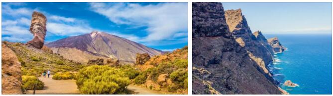
The main attraction of the Canary Islands is an extinct Teide volcano (3718 m) – rises in the center of the island of Tenerife. The volcano formed about 180 thousand years ago in the caldera of an older volcano, the height of which reached 6000 m. The volcano is protected by the national park of the same name (Teide national park). The park was created in 1954 and became the first national park in Spain .. Lava flows have formed bizarre landscapes here, similar to those of the moon. Among them, unique endemic plants grow and about 700 species of insects, various reptiles and birds live. The park has two tourist centers – El Portillo (El Portillo) and Canada Blanca (Canada Blanca), from where excursions to the volcano depart. There are 10 hiking trails of various lengths and levels of difficulty along the slopes of the volcano. A cable car has been laid from the highway encircling the Teide volcano to a height of 3550 m. In just 10 minutes, tourists are in the immediate vicinity of the summit of Teide. Here is an observation deck from where you can see all the islands of the Canary archipelago. The remaining 168 m can be climbed on foot, however, this requires permission from the administration of the park, located in Santa Cruz. Teide National Park is surrounded by the Corona Forestal natural park, where endemic Canarian pines grow.
Also on the island of Tenerife, it is proposed to go on a hiking trip around its capital – Santa Cruz (Santa Cruz) – Anaga Mountains, which occupy the entire north-eastern part of the island of Tenerife. On the slopes of the mountains there is a natural park of the same name with an area of about 15 thousand hectares. More than 100 endemic plant species grow here, among which is the Canarian pine. There are several hiking trails in the park. In addition, on the south coast of Tenerife, in the vicinity of El Medano beach, on the slopes of the Montana Roja volcano (Montana Roja), is a natural reserve, home to hundreds of bird species and more than 100 plant species.
According to Percomputer, the island of Lanzarote is truly unique. Here on an area of 795 sq. km there are about 300 volcanoes, whose eruptions in the 18-19 centuries formed a bizarre landscape. The island is under the protection of UNESCO and has the status of a biosphere reserve. The southwestern part of the island of Lanzarote, occupied by the peaks of extinct volcanoes, craters and vast lava fields, is protected by the Timanfaya National Park (Timanfaya national park). The modern landscape of the park was formed as a result of the eruptions of hundreds of volcanoes that occurred between 1730 and 1736. It was one of the worst natural disasters recorded in the history of mankind. For 6 years, lava flows covered an area of 200 square meters. km, on which about 50 villages were located. Walking tours are arranged in the park (there are two hiking trails), excursions by bus (in the northern part of the park, where in some areas the surface temperature of the earth reaches +100 degrees, and at a depth of 10 m – +600 degrees!) And on camels (in the southern parts of the park where you can see the most incredible volcanic formations). The strength of the heat of the local “Fire Mountains” (Montanas de Fuego), as the locals call them, can be understood when the guide pours a bucket of water into a small earth fault, and the water bursts out in a few moments in the form of a column of steam; or in the restaurant “El Diablo”, all dishes of which are cooked on a natural brazier – a grate installed above a recess in the ground.
The landscapes of the island of Palma also remind of the volcanic origin of the Canary archipelago. The northern part of the island is occupied by the crater La Caldera de Taburiente, protected by a national park, and the southern part by the chain of dormant volcanoes Cumbre Bieja. Protected areas occupy about 35% of the island’s area. This is a great place for hiking and outdoor recreation away from the hustle and bustle of big cities. La Caldera de Taburiente National Park (La Cadera de Taburiente) was founded in 1954 in the northern part of the island in a huge caldera, formed as a result of underwater eruptions and further erosion. The circumference of the caldera is 28 km, the diameter is 10 km, and the depth is 1500 m. The mountains surrounding the caldera reach a height of 2500 m, in winter their peaks are covered with snow. On the highest mountain, Roque de los Muchachos (2426 m), one of the world’s most important astrophysical observatories is located. Most of the caldera is covered with dense pine forest. The park is home to many birds, bats, reptiles and about 500 species of invertebrates. There are no roads in the park, so you can explore it only by going on foot.. There is a campsite on the territory of the park, but in order to stay here for the night, you must obtain permission from the administration of the park, located in its southern part.
On the eastern fringes of the La Caldera de Taburiente National Park lies the Las Nieves Natural Park 51 sq. km. There are hiking trails in the park. The most popular of them pass through the part of the park called Los Tilos. Los Tilos is a vast laurel forest. Similar forests covered Europe as early as the Tertiary period. Nowadays, laurel can grow here as a result of excessive moisture, because it is here that moist air masses from the ocean come along with the northeast trade winds. In addition to lush vegetation, numerous streams, rivers and waterfalls formed in such humid conditions, transforming the local landscape for centuries, now deep ravines stretch for many kilometers here.
A whole chain of dormant volcanoes Cumbre-Bieha (Cumbre Vieja) stretches in the southern part of the island of Palma. Today these places are protected by a natural park. For many centuries, the volcanic landscape of the park was formed (the last eruption happened here in 1971). Now lava fields stretch here, in the middle of which the majestic peaks of volcanoes rise. The famous Ruta de los Volcanos hiking trail runs through the entire park. On the southern edge of the park, in close proximity to the southern coast of the island of Palma, is the village of Fuencaliente. The village is surrounded by the peaks of the volcanoes San Antonio and Teneguya (it was he who erupted in 1971), which offers a beautiful view of the ocean and the islands of Gomera and Hierro.
Excellent opportunities for hiking are available on the island of Gomera. In the center of the island rises the Garajonay mountain range with the highest elevation of 1487 m, protected by the national park of the same name. Garajonay is a unique place. On its slopes, the rarest evergreen deciduous forests in northern Africa, consisting mainly of laurel trees, stretch. In addition, Garajonay is home to canaries named after the archipelago. Garajonay National Park (Garajonay national park) was established in 1981. It occupies a tenth of the island (about 40 sq. km). Since 1986, the Garajonay National Park has been included in the UNESCO World Heritage List. About 70% of the territory of the park is occupied by dense evergreen deciduous forests with a predominance of laurel, which covered Europe in the Tertiary period. The presence of such forests in these latitudes is explained by the abundance of moisture brought by trade winds from the ocean. Due to the high humidity in these places, fog often occurs. On clear days, from the top of Garajonay, you can see the nearby islands of the Canary archipelago. Cozy mountain villages are located on the territory of the National Park, where you can get by going on a hiking trip through the park.
Interesting island of Hierro. Since 2000, it has been declared by UNESCO as a specially protected natural area. Here you can see dense pine forests, steep cliffs more than 1 km high and endemic Canarian lizards, reaching a length of 1 m, which existed in the Tertiary period.
2 km from the northern coast of the island of Fuerteventura is the protected island of Lobos (Isla de Lobos) with an area of 5 square meters. km. Tourists are invited to go to the island on sightseeing boats with a transparent bottom. The island can be explored on foot in a few hours, since there are plenty of hiking trails here.
Of the natural attractions of the island of Gran Canaria, its highest points can be distinguished – the volcanic peak of Pico de las Nieves (1949 m) and Mount Roque Nublo (1813 m), on top of which rises a huge stone monolith 80 m high, formed as a result of erosion. From here you can see not only the entire island of Gran Canaria, but also the island of Tenerife with the Teide volcano. The local places are very picturesque – the slopes of the mountains are covered with tropical forests, in the middle of which there are small villages. Also on the island of Gran Canaria it is worth looking at the largest volcanic crater of the island – Bandama. Its diameter is 1000 m, and the depth reaches 200 m. You can go down to the bottom of the crater along a stepped slope, the descent takes about 1.5 hours.
")


